 |
|
|
|
Alien Plants
|
| |
|
The effect of alien plant species on native plant richness
and community composition in urban
mid-age Sugar Maple (Acer saccharum) dominated forests
in London, Ontario
Page 2 of 9
|
| |
|
Methods
Study Areas
Ten sites were chosen for study either within the boundaries of the City of London, or within 5 km of the city limits. All sites were restricted to mid-aged Sugar maple (Acer saccharum) stands. The sites were on public land, either in city parks, conservation areas, or a provincial park (Fig. 1). Stands were chosen for their varying degree of invasion by exotic plants. All sites were used to some extent for recreational purposes (i.e. hiking, bicycling, and an active sugar bush.). Permission to do research in the sites was obtained from the respective organizations, prior to sampling. Preliminary screening for suitable sampling sites was done by consulting air photos. Most sites were visited in June to determine suitability, size, and general boundaries.
Vegetation community boundaries were defined using air photo inspection and ground truthing of the actual site. Size of the site (Table 1), as defined by the community boundaries, was also a consideration. This was measured from air photos using a planimeter. Average distance to field, road, or river edge was derived by dividing each site into four quadrants and measuring the shortest distance to the edge in each and averaging this value. Generally, potential sites that were too small (<5000 m2) were rejected. Homogeneity of the tree species composition, size class distribution, understory vegetation, and topography were used to determine the boundaries.
|
| |
|
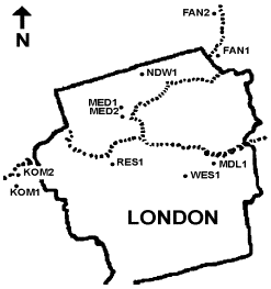
Figure 1.
Map of London, Ontario showing city
boundaries and approximate locations of study sites. Thames River shown as
broken line. |
 |
|
| |
|
Sampling Procedure
The sites were sampled in late August, 2000. Depending on the size and shape of the community at each site, the longest possible transect was chosen through the site. The length of each transect was estimated, and the distance between sampling points was calculated so that a total of twenty, evenly distributed quadrats could be laid.
The location of the first sampling point was chosen haphazardly within three metres of the site boundary. The transect was continued towards the centre of the site. At each sampling point, one 1 m2 quadrat was placed on the ground. The vascular ground-layer plant species and shrubs occurring in the quadrat were listed. The abundance of each species was noted using a Domin-Krajina cover-abundance score (Table 2., Mueller-Dombois and Ellenberg 1974). This was later converted into mid-point percent for analysis purposes.
|
| |
|
Table 1. Area, distance to edge, and general
level of invasion of sites
|
| |
|
Site |
Average Distance
to Edge (m) |
Area (m2) |
Invasion
Level |
|
FAN1 |
80 |
14 100 |
High |
|
FAN2 |
104 |
17 600 |
High |
|
KOM1 |
180 |
43 500 |
Low |
|
KOM2 |
89 |
17 000 |
High |
|
MDL1 |
172 |
29 000 |
Low |
|
MED1 |
45 |
7 300 |
Medium |
|
MED2 |
61 |
5 700 |
Low |
|
NDW1 |
158 |
27 000 |
Low |
|
RES1 |
122 |
12 600 |
High |
|
WES1 |
122 |
11 800 |
Medium |
|
| |
|
Table 2. Domin-Krajina cover abundance scores,
corresponding percent cover, and mid-points
|
| |
| Score |
Cover (%) |
Mid-Points (%) |
|
10 |
100 |
100 |
|
9 |
>75 |
87.5 |
|
8 |
50-75 |
62.5 |
|
7 |
33-50 |
41.5 |
|
6 |
25-33 |
29 |
|
5 |
10-25 |
17.5 |
|
4 |
5-10 |
7.5 |
|
3 |
<5 |
3 |
|
2 |
<1 |
0.5 |
|
1 |
seldom, insignificant cover |
0.1% |
|
|
(Mueller-Dombois and Ellenberg 1974)
|
| |
| The Domin-Krajina score of moss, rocks,
bare ground, small, medium, and large woody debris, litter, and roots was also
noted. The overhead canopy cover directly above the quadrat was estimated
similarly. The distances to the nearest water body (lake or river), den tree or
snag were also recorded. A list of vascular species was begun
immediately upon arrival at the site and continued for the duration of the
visit. Any species not identified in the field were collected for later
identification by an expert, or by comparison with herbarium specimens.
At random points along the transect, prism
sweeps were taken to determine the species composition, basal area, and size
class distribution of the trees (Lee et al. 1998). A prism of factor 1
was used so that tree counts converted directly into basal areas of m2/ha
(Mueller-Dombois and Ellenberg 1974). At each prism sweep location, a soil core
was sampled using an Oakfield soil corer. Using field criteria outlined in Lee et
al. (1998), soil texture and moisture regime were determined and recorded.
A general description of the site was
made that consisted of describing the overall abundance of saplings, the amount
of woody debris, and standing snags in the site. As well, the intensity, and
extent of disturbances such as sugar bush operations, logging, recreational use,
flooding, fire, browse activity, etc. were noted (Lee et al. 1998). The
overall condition of the site (poor to excellent) was estimated. |
| |
| Data Analysis The data were entered into a database. Plant names were
entered as seven letter codes. Codes were linked to a master database (Bowles et
al. 1994) containing plant species information such as native or alien
status and conservatism coefficient or weediness score. Mean conservatism
coefficient (MCC) was used as a measure of the pristineness, or lack of
disturbance, of a site (Oldham et al. 1995). Plants more specialized in
habitat or condition and conserve themselves to very specific environments and
communities are assigned higher conservatism coefficients, hence quadrats with
high MCCs contain more plants unlikely to be found in disturbed habitat. This
value varies from 1 to 9. Most woodland species have a conservatism coefficient
of around 6. Similarly, weeds have been assigned a weediness score, where -1
represents a weed with low invasiveness, and -3 a very invasive alien species.
The mean of this score (MWS) can be used like MCC to measure the representation
of weedy species abundance. Data were organized into two general scales: site
and quadrat. Site variables were overall site condition, tree data, disturbance
measures as well as means of quadrat data. Quadrat variables were species
richness and percent cover of plants, from which MCC and MWS were derived.
A disturbance index was generated by grading each site in
several categories of disturbance for both intensity and extent throughout the
site. A score of 0 indicated no disturbance and 3 indicated high levels of
disturbance. The extent score was multiplied by the intensity score for each
disturbance type and these were summed for each site.
Organization and queries of the data were done in Corel
Desktop Database and Quattro Pro 8. The statistical functions of Quattro Pro
were used to carry out preliminary exploration such as comparison of means,
simple linear regressions and other univariate statistics. One-way ANOVAs with
Tukey’s multiple comparisons tests, linear regressions, and principal
components analyses of site and quadrat variables were done using SPSS. Data
were tested for homogeneity of variance and normality of residuals using SPSS.
|
| |
|
Previous Page
Next Page
Copyright © Peter Moc
|
|
|
| |
| |
|

